Andrew
Collins at Gunung Padang
E
A R T H Q U E S T vN E W S
ANDREW
COLLINS NEWSLETTER - MAY 2015
In
this issue: News of the Origins 2015 Conference * Andrew's visit to Gunung
Padang * The Bandung Obsidian Industry * The Search for Java's Batu Bedil - the
Gun Stone * Trans-Pacific Contact * Palaeolithic origins in Sundaland * The Stone
Chambers and Stone Walls of New England * America's Stonehenge * Mystery Hill's
Star Alignments checked
Origins 2015 – Britain’s premier
ancient mysteries conference, organized jointly by Megalithomania and the Questing
Conference, is now go. The date is Saturday, November 7th.
The venue is
Arts Two lecture theatre, Queen Mary University of London, Mile End, London E1
4NS.
The speakers are as follows: Graham Hancock, delivering the very
latest evidence on a global lost civilization wiped out by a comet impact at the
end of the last Ice Age – the subject, of course, of his brand new book Magicians
of the Gods out in September.
Jim Vieira, the United States’ premier
expert on the North American giant tradition, who flies in to deliver his lecture
and launch the book Giants on Record, co-authored with Origins and Megalithomania
organizer Hugh Newman.
Hugh Newman will present his own lecture at the
event, the details of which will follow soon.
Javanese geologist Danny
Hilman Natawidjaja will outline via video link his work at Gunung Padang in Java,
showing its connection to Plato’s story of Atlantis and the cataclysm that
devastated the world at the end of the last Ice Age.
Lynn
Picknett and Clive Prince, co-authors of The Templar Revelation, reveal the true
foundations and history of human science and astronomy, while I will deliver the
following talk:
"Over the past year Andrew has been travelling the
world exploring the greater antiquity of prehistoric sites from Göbekli Tepe
in southeast Anatolia to Gunung Padang in Indonesia's West Java province, Mount
Carbon in West Virginia and Peru's Tiahuanaco. This work forms part of his new
book project showing that hybridization between different types of archiac and
more modern humans gave rise to civilization tens of thousands of years earlier
than what history suggests. He reveals the fruits of his endeavours and begins
to build a picture of a global belief in the importance of the northern heavens,
in particular the Milky Way and Pole Star. These were personified as a primeval
goddess of life. Although she takes many forms, this stellar goddess is primarily
associated with key Pole Stars of the distant past, such as Deneb in Cygnus and
Vega in the constellation of Lyra. As the so-called Weaver Princess of Island
Southeast Asia she is said to have mated with a supernatural or heavenly dog to
give birth to the human race. It is a tradition that can be traced from Java all
the way across to China and Tibet. Andrew reveals the true origins of these strange
beliefs in a supernatural ancestor, tracing its origins to the indigenous peoples
of Lake Baikal in southern Siberia. They for millennia have believed in their
descent from a supernatural wolf. Why? Why a wolf? Andrew explains in this brand
new lecture."
Then,
on the Sunday, I return to my London roots and conduct a tour around the East
End, explaining its pentagonal geometry based on the churches of architect Nicholas
Hawksmoor, and taking delegates on a tour of the sites associated with Jack the
Ripper (the two themes being brought together in Alan Moore’s graphic novel
“From Hell”, which went on to become a great film featuring Johnny Depp).
It is a morbid subject, I know, but it is one filled with magical connotations
and speculation of some kind of Masonic conspiracy to cover up the truth. In addition
to this, I shall be teaching Cockney rhyming slang, and explaining its importance
to East End life in the nineteenth century. We end the day, hopefully, in The
Ten Bells, one of the main pubs featured in the Ripper mystery, which remains
a thriving London hostelry, and afterwards go for a “Ruby Murray”, that’s
a curry, in one of the Asian restaurant’s in nearby Brick Lane.
Early
bird prices for the Saturday conference are £48, with the price rising to
£52 after the first 50 tickets sold.
For those who want the whole
Saturday and Sunday experience, the early bird tickets are £62, with the
price rising to £66 thereafter. Don’t delay. Register now. It should
be a great weekend, full of revelations and great memories.
For further
information and immediate registration go to:
http://www.andrewcollins.com/page/conference/conferencenews.htm
(please note this page is still under construction, so expect a few holes)
Remember also that there is still time to come with us on our 4 night/5 day
mini tours to Göbekli Tepe and the surrounding area in May and September
2015. We visit the ancient city of Harran, home of the Chaldeans, Sabaeans, astrology
and Hermetica; Göbekli Tepe’s sister site Karahan Tepe, and the various
sites in Saniurfa, where we stay, including the birthplace of Abraham and new
archaeological museum, which features a permanent exhibition of material from
Göbekli Tepe’s Pre-Pottery Neolithic culture.
For more information
and registration, go to:
http://andrewcollins.com/page/events/Gobekli_break_0515.htm
Also I am with Brien Foerster and Hugh Newman in June/July on the Ancient
Technologies tour of ancient Peru and Bolivia, organized by Hidden Inca Tours
and Megalithomania. It includes a full day solstice celebration in Cuzco, known
as Inti Raymi. The sites of the main tour are Lima * Cuzco * Sacred Valley * Ollantaytambo
* Machu Picchu * Puno * Lake Titicaca * Sillustani * Cutimbo * Tiwanaku * Puma
Punku and much more. Dates are June 19/29, 2015, and then June 29/July 3 for the
extension to Nazca, Ica & Paracas. For more information and registration:
http://www.megalithomania.co.uk/peru2015.html
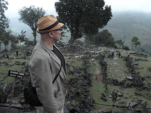
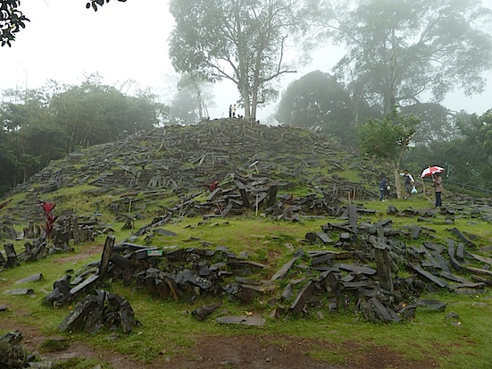
GUNUNG PADANG VISIT
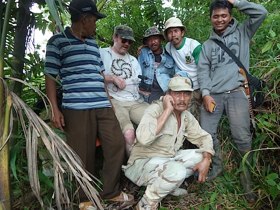
Recently, I returned from Java where, with
Hugh Newman, I visited the megalithic complex of Gunung Padang in the company
of Javanese geologist Danny Hilman Natawidjaga. It consists of a series of stone
settings and rock mounds made from log-like columnar blocks of andesite. These
are situated on five stepped terraces on the upper slopes of a large hill. The
monuments seen today date to around 600 BC, according to recent carbon-14 dating.
Yet beneath the current structures are further rows and groupings of columnar
blocks that Danny and a multidisciplinary team suspect were placed down as part
of a much older structure, built in stages, rather like the pyramids of Central
and South America. Radiocarbon dating of the first lower layer (layer 2) has revealed
radiocarbon dates in the range of 5000 BC, while an even lower level has provided
dates suggesting the presence of a built structure pre-8000 BC, and arguably as
early as 12,000 BC. Indeed, coring of the site has indicated the presence of an
even deeper levels going back as early as 25,000 BC.
Geo-physical and geo-radar surveys, as well as multiple soundings conducted at locations right across the hilltop, indicate the presence of a vertical hollow that is most likely a lava tube. Yet extending from this horizontally towards a position corresponding to the rock wall dividing terraces 1 and 2 is a horizontal tunnel-like structure that might well have provided access from the monument to the lava tube, and thus could have been artificially created or at least artificially enhanced. It is worth pointing out that the Pyramid of the Sun at Teotihuacan in Central Mexico also has a volcanic lava tube beneath it (something pointed out to me by Graham Hancock, recently).There is a clear relationship between whatever went on in the past at Gunung Padang and volcanoes, not simply because of the presence within its centre of a lava tube, but also because the entire monument is directed towards a supervolcano with two peaks.
Terrace
1 at Gunung Padang viewed from the north
(copyright, Andrew Collins, 2015).
One,
the closest one, is called Gunung (Mount) Gede, and other, behind it, is Gunung
Pangrango. To be more precise Gunung Padang’s central axis, calculated by
British engineer Rodney Hale at 342 degrees east of north, targets the eastern
caldera of Gunung Gede, which lies around 15 miles (22 km) away from Gunung Padang
(pronounced Ger-domg Pa-dang).
Whilst staying at Gunung Padang (on a mattress
in a bare room that resembled something out of the TV show "I'm A Celebrity
Get Me Out of Here," complete with insect-inspired "Bushtucker Trials"!)
I was able to speak at length with a local guide and guardian of the site. With
Danny Hilman translating, he provided me with a comprehensive rundown of every
folk legend and tradition associated with Gunung Padang allowing me a full insight
into the site's spiritual dimension.
I shall publish this knowledge in
due course. However, some of this material is included in the following video
I put together on Gunung Padang when at the site:
https://www.youtube.com/watch?v=0ddIae6eLB8
Also a second video featuring our visit put together by Hugh Newman:
https://www.youtube.com/results?search_query=gunung+padang+andrew+collins
One of the things the guardian did confirm is Gunung Padang's absolute orientation towards the Gede-Pangrango stratovolcano, which he said was seen as a manifestation of God himself. Although as a Moslem he probably had in mind Allah when he said these words, very likely these ideas stem from much earlier Javanese, or more correctly Sundanese, traditions attached to Gunung Padang, which could easily be many thousands of years old. Back then the volcano was most likely the expression of a creator god seen in terms of a god of fire, similar to beliefs and practices still attached to other Javanese and Philipino volcanoes.Our purpose for the visit to Gunung Padang was not simply to investigate its apparent greater antiquity, but also to try and investigate the material culture behind its construction.I was perplexed by the fact that to date no identifiable stone tools have been found at the site, something that continues to strike me as odd.
Gunung
Padang's Terrace 1 from the south
(pic copyright: Andrew Collins, 2015).
Just
one strange object has been found, and this is made of andesite and, in my eyes,
resembles a trowel. It does not conform to any known style of stone tool manufactured
by our ancestors, and some might dismiss it as a geofact - that is a natural object
that has the appearance of being artificially created. Whatever it is, it cannot
have had any obvious functional use as it would have broken easily. Equally, it
cannot have been in the earth long, as this would have crushed it.
BANDUNG
OBSIDIAN INDUSTRY
Yet I was struck by the fact that in the Bandung river
basin east of Gunung Padang, which sits towards the south edge of the Cianjur
river basin, and well as at Bogor, a city just to the northwest of the Pangrango-Gede
stratovolcano, considerable evidence has been found for the existence of a highly
organised culture that produced flake tools made mostly from the volcanic glass
known as obsidian. Sites belonging to what is known as the Bandung obsidian industry
have been located at settlement sites located on hill slopes around the edge of
the river basin, which was once occupied by an enormous lake. This came into existence
when lava from a nearby volcano created an impenetrable wall damning of a major
river course as much as 125,000 years ago. Yet more important is the fact that
the Bandung Lake started to disappear as much as 20,000 years ago, with its remaining
water disappearing as recently as 4,000 years ago. Since the principal sites of
Bandung's obsidian industry are located on raised ground above the original extent
of the lake prior to 20,000 years ago, it seems likely that they were positioned
so as to take advantage of the lake's natural resources. If correct, the implications
of this are enormous and suggest that this culture might have existed as much
as 20,000 years ago (the Bandung obsidian industry is generally attributed to
the Mesolithic and Neolithic periods of Javanese history, although its Palaeolithic
roots seem obvious - see below).
In other words, if we are looking for a material culture responsible for the earliest construction phases at Gunung Padang, then surely the best candidate by far is the indigenous population responsible for the Bandung obsidian industry.
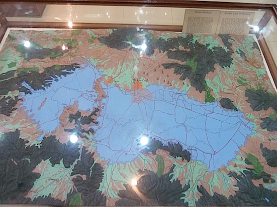
The
Bandung Lake as it would have appeared 20,000 years ago. From a 3D model in Jakarta's
Museum Nasional. Settlments of the Bandung obsidian industry are marked by red
cones (pic copyright: Andrew Collins, 2015).
Obsidian is generally considered a high status material due to its exquisite appearance,
which when cut makes it look like a cut gem; its unparalleled sharpness, and also
its otherworldly attributions (it is often seen as a stone of heaven, or the congealed
blood of gods or the embodiment of fire - see my book Gobekli Tepe: Genesis of
the Gods).
However, as mentioned earlier, to my knowledge no stone tools
have ever been found at Gunung Padang.
I
have suggested to Danny Hilman that in the future he initiate a search of Gunung
Padang and the surrounding valleys in the hope of finding stone tools that might
have been used by the population responsible for the different phases at Gunung
Padang. Yet in the meantime I wondered whether there might be another way of strengthening
the link between the Gunung Padang monument and the presumably indigenous population
responsible for Bandung's obsidian industry.
THE SEARCH FOR THE GATEWAY
SITE
The Cianjur and Bandung river basins are divided by a north-south
running mountain range that is difficult to cross other than via prominent river
passes. An examination of Google Earth revealed that the most likely gateway between
the Cianjur and Bandung districts was the deep valley created by the Cisokan river
and its tributaries. A traveler can follow the Cisokan towards its source in the
mountains, and then connect with rivers running east into the Bandung basin. I
looked for other possible candidates for this gateway site, but none made better
sense.
Inspired, I have to admit, by a strange meditational vision on
this subject, I felt sure that the spiritual and strategic gateway between the
two river basins was occupied by an important megalithic monument - part natural,
part artificial. It was then that I came across a site named Batu Bedil, a megalithic
structure on a mountain ridge overlooking the Upper Cisokan river valley. Its
name is Javanese and means the “Gun Stone”. It consists of a series
of large megaliths that are said to possess magical qualities, in that if anyone
ever tries to remove them from their location the stones will mysteriously return
to their original position. More disconcerting was the news that Java’s main
electricity generating company were in the process of building two dams in the
Upper Cisokan Valley, one of which is located immediately beneath the mountain
on which Batu Bedil is situated. Indeed, there was some indication from their
environmental damage report that slippage from a surge tank being created immediately
below this megalithic structure could either damage or destroy it.
I decided
that with Danny Hilman's help I was doing to do whatever it took to investigate
this previously unrecorded megalithic structure in order to ensure its future
preservation. Moreover, confirmation of its existence might help establish the
connection between the builders of Gunung Padang and Bandung's obsidian culture.
CLIMBING MOUNTAINS - THE SEARCH FOR JAVA'S BATU BEDIL
So after one failed attempt to reach the mountaintop site, Hugh Newman, Danny Hilman, a hired driver and myself returned to the Cisokan area in a 4 x 4 vehicle and allowed local villagers to direct us towards the location of Batu Bedil, which was not easy to find. Yet then, as we left the Bandung district and entered neighbouring Cianjur we found ourselves in an enchanted forest. We journeyed ever closer to our destination, which could not be any more than a few miles away now, and then saw in front of us a heavy digger and about a dozen or so workers engaged in making the road we were on! In other words, we were going no further in our vehicle. At first I was deeply frustrated, and gave up all hope of going any further. Yet then I had an idea we could hire the rally bikes being used by the workers to ferry people and materials from one station to another. So after some discussion with the workers and foreman - who was dressed in army fatigues and looked like a Javanese version of Charles Bronson - we quickly we found ourselves on the back of powerful motorbikes, navigating hills and valleys, where streams and pot holes were traversed on bridges composed of nothing more than a few bamboo canes loosely placed side by side.
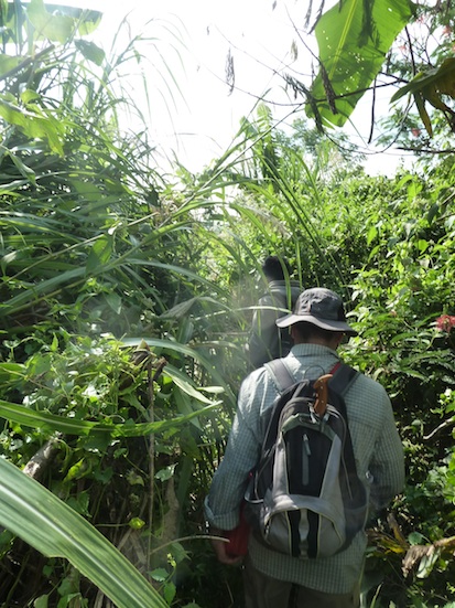
Danny
Hilman on the way to Batu Bedil
(pic credit: Andrew Collins, 2015).
After
a nail-biting, 30-minute journey we left behind the bikes and ascended a mountain.
Having crossed its razor-like summit, where a tumble either side might well have
led to a fatal fall, we entered deep jungle, interspersed here and there by a
few areas of cultivation. Here grew rice and, curiously, in one grove a mass of
tall sunflowers, something I had not expect to behold on the top of a mountain
in Java. Finally, after a walk of around 40 minutes - during which Danny was stung
four times by dive-bombing hornets - we ascended one final ridge and came across
the grouping of megalithic stones.
The largest stone was approximately
2 m in length and around 0.45 m in width. It lay horizontal, and nearby was another
slightly smaller monolith which, we discovered, had previously been placed on
top of the larger stone at the same orientation. It was this configuration that
had given rise to the name Batu Bedil, the “Gun Stone", as it resembled
a large cannon on top of its gun carriage. The “cannon” pointed roughly
westwards over the river valley below (the azimuth was calculated by Rodney Hale
based on the location of the sun at a specific time).
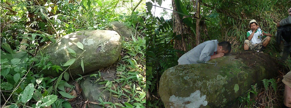
The
stones of Batu Bedil in Java's Cianjur district. On the left the gun stone itself,
and on the right geologist Danny Hilman Natawidjaja examines the gun stone's "gun
carriage" (pics credit: Andrew Collins, 2015)
It
was then that I learnt from one of our guides the reason why the stones are said
to possess magical properties, for if the “cannon” is dislodged or transported
from its carriage, as it is today, then it would always return mysteriously to
its original position. If so, then clearly something had now gone wrong, as the
"cannon" stone is now dangerously close to the edge of the slope, and
could easily slide further down if any land slippage were to occur during the
construction of the nearby dam.
Several other, slightly smaller stones
lay nearby, some of which have slipped down the bank. We were told not to venture
too close as the undergrowth contained a very specific poisonous plant. Just brushing
against its leaves could cause a severe skin reaction. So Hugh and I attempted
to record what we could see as Danny got down to examining the composition of
the megaliths.
Apparently, they are rounded andesite blocks, just like the building material at Gunung Padang. He asked the guides if there were similar stones elsewhere in the area, and they said no. This baffled Danny who concluded that the megaliths must have been brought to the mountaintop summit for a specific purpose. From the elevated position of Batu Bedil, on the western limits of the Gunung Batu Bedil mountain ridge, there would have been a clear view across to the north, west and south. You would have been able to see all the surrounding river valleys, including those of the Cisokan to the northwest and Cirumaris below to the west (on which the Upper Cisokan Dam is being built). This would have made it a perfect vantage point both strategically and spiritually. Indeed, the fact that it is located close to the border between the ancient Bandung and Cianjur districts confirms that it really could have been a kind of gateway site, acting as a spirit bridge between different zones or kingdoms.
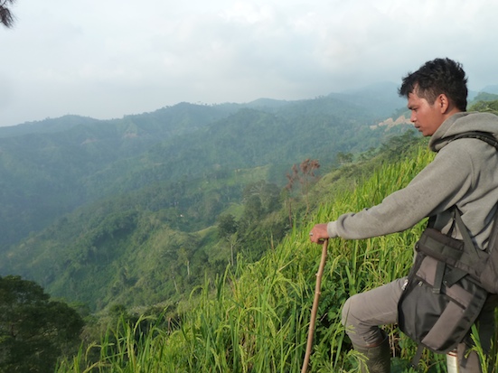
The
view from the summit of Java's Gunung Batu Bedil
(pic copyright: Andrew Collins,
2015).
One
final piece of folklore we picked up from the guides as we examined the stone
settings is that when Java experiences a national crisis, Batu Bedil will sound
a loud boom like a real cannon. On hearing this, I felt it possible that the site
might be connected to concepts relating to the sovereignty of the land, and might
well have a more specific importance to West Java’s spiritual matrix than
I had previously imagined. Yet with the light beginning to fade it was time to
leave, otherwise we could find ourselves travelling across rough terrain on the
back of motorbikes in the darkness, which I did not relish on little bit. So we
began the near torturous journey back across the mountain summit and eventually
reached the waiting motorbikes and their owners.
As we were coming away
from Batu Bedil, something curious happened. No more than a couples of hundred
metres from the site we suddenly heard a loud boom, very much like the sound of
a cannon sounding. Now, I have no idea what caused this, and can only assume it
was connected in some manner with the construction work going on in the valley
far below. Yet it was a strange synchronicity, especially after hearing about
the legend of the boom made by Batu Bedil only shortly beforehand.
The
rally bikes carried us back to the 4 x 4 vehicle, and then negotiations began
as to how much all this was going to cost us. Stupidly, we had not agreed on prices
beforehand, and machete-wielding forestry workers and a foreman dressed in army
fatigues are not the sort of men you don't want to upset. Luckily, Danny was able
to argue with them in our favour, and so we were able to pay them a suitable,
though still very costly price, making everyone happy, allowing us to leave the
area just as darkness fell.
Our
guides to Batu Bedil, plus Hugh Newman and Charles Bronson in fatigues!
(pic
copyright: Andrew Collins, 2015)
We
arrived back in Bandung later that evening, and celebrated with a few bottles
of beer sneaked into the hotel by the obliging staff (Java is a dry Moslem country,
remember). I'll be honest, there were certain times that day when I genuinely
felt we would barely escape with our lives, never mind reaching the hotel by a
sensible time.
I also thought about why I actually do this sort of things
– claim mountains in foreign countries, putting my life and wellbeing at
risk. The answer perhaps, although inadequate, came back to me. It is because
it feels the right thing to do, since it connects you with a genius loci, a spirit
of the place, that has called you for some very specific reason - a reason you
might never come to understand yourself.
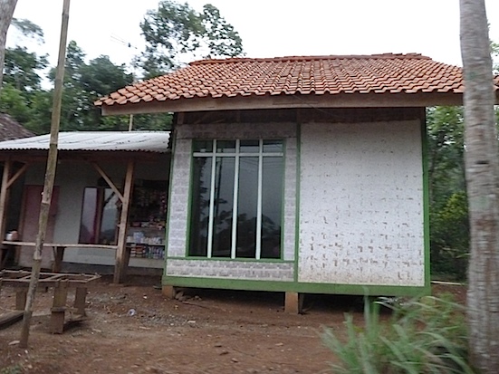
TRANS-PACIFIC CONTACT
One thing I noticed both on the way to and from the Cisokan valley was the
predominance of single story houses and buildings made of slatted bamboo walls.
It seemed absolutely unique to the this remote region of West Java. I asked Danny
Hilman about this, and he confirmed it was a very ancient style of building still
practised by the people of this region. This intrigued me as the country most
obviously associated with buildings made from slatted bamboo walls and roofs is
Japan. To find this exact same style of building here in Java could imply some
kind of cross-cultural contact at a very early stage in the island’s history.
Bamboo
house in the wilds of West Java's Cianjur district
(pic copyright: Andrew Collins,
2015).
Oddly,
the previous week Hugh and I had visited Vietnam briefly on the way to Java, and
here I noted the similarity between the physical appearance of some Vietnamese
people and the heads of a large number of Olmec statues from Central Mexico. They
both had the same eyes, same shaped heads, and same downturned mouths. The resemblance
was striking. What all this meant, I was not sure. Yet what I did know is that
examples of a primitive script used by Japan’s Jomon culture, which thrived
ca. 10,500-300 BC, has been found on some Olmec artefacts. This suggested that
peoples from either East or Southeast Asia might have been the ancestors of the
Olmec peoples of Mexico.
THE HOABINHIAN
Although the Jomon
culture did not properly exist outside of the islands of Japan its very earliest
forms of pottery have been compared with those of Vietnam’s Da But culture,
which thrived 5000-1000 BC. Both the Jomon and De But cultures were hunter-gatherers,
not agriculturalists. The stone tools of the early Jomon have also been compared
with those of a Palaeolithic culture known as the Hoabinhian, which existed in
Vietnam ca. 13,000-3000 BC.
The Hoabinhian possessed a prolific pebble
tool (that is, tools made using the centre sections of large pebbles, which are
then rerouched into shape) and flake industry. More significantly, the Hoabinhian
thrived also on the island of Sumatra and, to a lesser degree, on Java. At the
time both would have formed part of the much larger Sundaland landmass, which
broke up into the islands of Indonesia and the Malay peninsula between ca. 14,000
and 10,000 years ago. Their toolkit included something referred to by archaeologists
as the Sumatralith considered the precursor to the Hoabinhain’s more widespread
pebble tool technology. In other words, Sundaland was quite possibly the true
origin point of the Hoabinhain, a Palaeolithic tradition that went on to influence
the foundation of Japan's Jomon culture.
PLATO
NEVER LIED
The idea that Sundaland might be the genesis point of many
Southeast and East Asian cultures and civiliations is argued by British geneticist
and author Stephen Oppenheimer in his truly ground-breaking book Eden in the East
(1998). Indeed, Javanese geologist Danny Hilman Natawidjaja argues in his book
Plato Never Lied (2013) that Sundaland was Plato's Atlantis, a theory that some,
more ancient high profile researchers are currently running with in new books.
Personally, I think this link is untenable, and maintain that everything weitten
by Plato concerning the location of Atlantis indicates that it was in the Atlantic
Ocean. Moreover, that its sunken lands are a memory of the original Bahaman landmass
with its main island being Cuba. It is this that I conclude in my book Gateway
to Atlantis, republished next year by Inner Traditions.
Back to the Hoabinhian
now. Since we know that on Sumatra it employed the use of obsidian to make flake
tools (i.e. flakes produced by percussion from larger pebbles), and that the same
culture existed also in Java, there has to be a chance that it is connected with
Bandung's obsidian industry. So is it possible that the Hoabinhian, or its successors,
were responsible for the construction of Gunung Padang? Such a realization would
be important indeed. It might also help throw better light on the true origins
of many East and Southeast Asian populations and cultures, which could well have
begun their journey on the Sundaland landmass before its eventual submergence,
ca. 14,000-10,000 years ago.
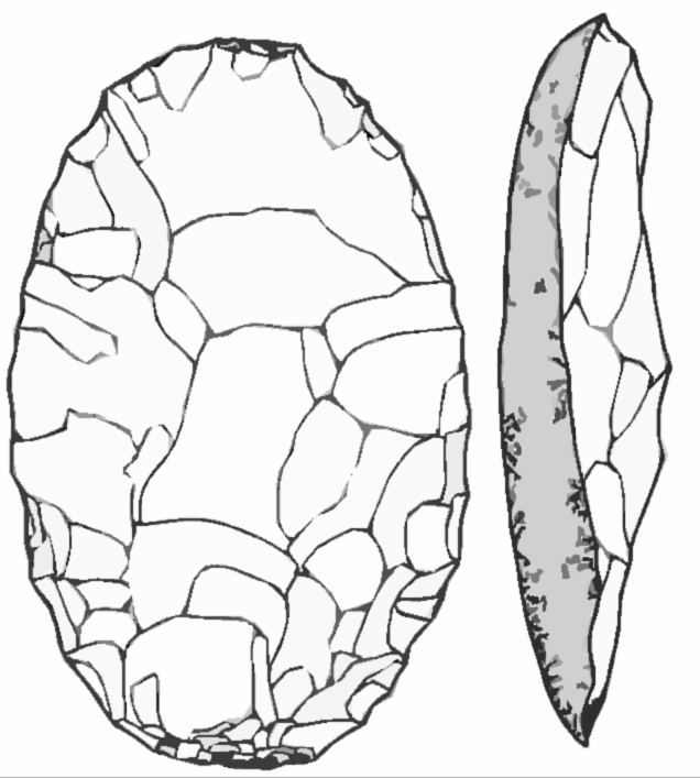
A
pebble tool known as a sumatralith.
Another thing both Hugh and I noticed when in Java were similarities between the layout and construction of Gunung Padang and those of Peruvian sites, most notably the mountaintop city of Machu Pichu. What is more, there seemed to be clear similarities between the physical appearance of the Javanese peoples and the facial features of carved stone heads at Tiawanaku in neighbouring Bolivia. There is a strong sense of connection between Peru. Bolivia and Java, which makes sense of ancient legends of transpacific voyages between the former Sundland landmass and the islands of Polynesia and Peru. It is something I shall hopefully be exploring further when in Peru and Bolivia with Hugh and Brien Foerster in June-July.
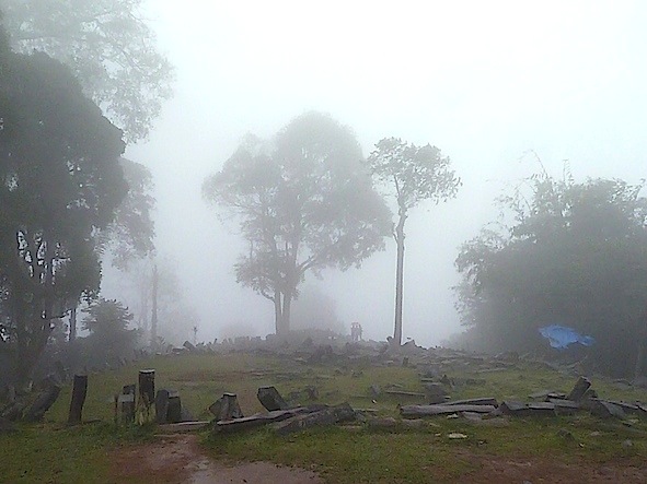
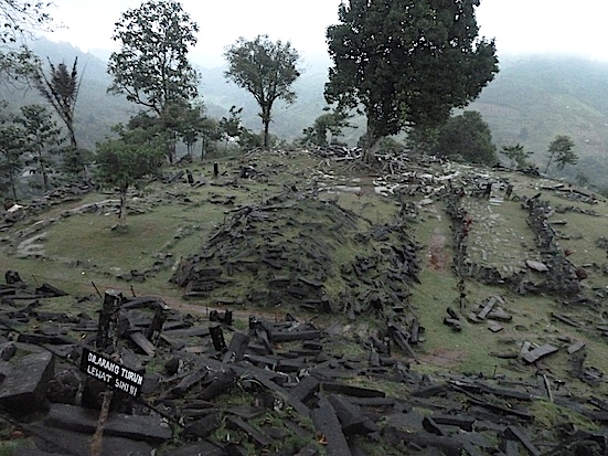
Gudung
Padang's Terrace 2 in the mist.
(pic copyright: Andrew Collins, 2015)
BACK
IN THE USA
Shortly after returning from Cambodia and Java, I embarked
on another adventure, this time to the United States. I was there to further explore
the accounts of giant skeletons being found with incredible frequency in Native
American mounds, and also to investigate the stone-building culture responsible
for a whole series of stone chambers and dry-stone walls right across New England,
and even into Canada.
Archaeologists will tell you that all these structures
date to historic times. They say they were constructed by early settlers –
hunters, trappers, farmers – most likely during the eighteenth and nineteenth
centuries. The chambers are dismissed as root cellars, places where root crops
were stored at a constant low temperature and humidity, while the walls are seen
simply as divisions between early colonial properties or pastoral enclosures for
animals. Tentative archaeological work to test these ideas has always appeared
to bear out this conclusion, even though the sites concerned are in areas where
Native American settlements and artefacts have invariably been found.
Greg
and Lora Little and I visited a number of these stone structures and came to a
quite different conclusion. For instance, in the Borderlands State Park, close
to the towns of Easton and Sharon in Massachusetts, we investigated a series of
stone walls in dense woodland. They are located more than a mile away from a colonial
house built within the park area, and seem to snake this way and that for some
distance before hitting a large glacial boulder (of which there are many in the
area), and then veering off in another direction, almost like they mark the track
of a giant invisible pinball bouncing off obstacles. Others seem to converge on
rocky outcrops, or even go over the top of them. The walls are of loosely stacked
rocks and rise to only one to two feet in height. This suggests they are unlikely
to have acted as boundaries to animal pens or individual properties.Tracing the
source of the stone walls can occasionally take you to the mouth of a small rock
shelter or cave, almost as if they commence at these features.
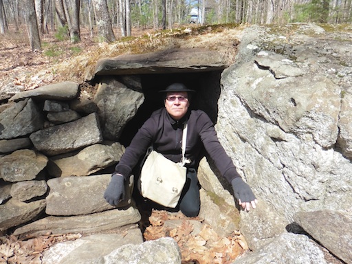
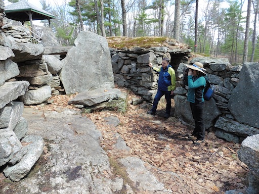
Andrew
Collins in a stone chamber to the south of America's
Stonehenge (pic copyright:
Andrew Collins, 2015).
We
also found at the end of one stone wall a recently exposed stone chamber, capped
with a huge table stone of some considerable weight. Its interior featured a carefully
built stonewall. Other similar chambers exist elsewhere in Borderlands, even though
the map guide makes no mention of them. That the stone chambers and natural caves,
which are of similar size, are located at the beginning of stone walls seems to
suggest they both symbolized the same thing to whoever built these walls. In other
words, the caves and chambers possessed the same basic functions.
WHO
BUILT THE STONE WALLS?
In my opinion the idea that colonials built all
the stone walls and cave-like chambers is grossly unhelpful in trying to determine
their true function and age. Since it is known that Native Americans inhabited
the area as early as the Early Archaic Period, some 9,000 years, I suspect the
walls and chambers are the legacy of an indigenous people that was once widespread
across the region. For me, the walls marked either the flow or boundaries of spirit,
seen in terms either of river-like energies, or as the presence of power animals,
whose movement could be channeled, blocked or directed by the presence of the
walls.
The small caves and constructed stone chambers are, in my opinion,
spirit houses, places of access to the other world. Inside them initiates, experiencers,
priests or shamans would have communicated with intelligences thought to inhabit
this otherworldly realm. Offerings, such as tobacco, are likely to have been deposited
at these openings to the otherworld to appease the spirits, while the bones of
ancestors would have been left inside them in order that they might guard the
location or continue their communication with the world of the living. It is also
likely that magical items were concealed within the caves and chambers so as to
prevent unwanted spirits from exiting the underworld and haunting the areas in
which they are located.
See the video “Borderland, MA: Stone Walls
& Hidden Stone Chambers” by Greg Little and featuring Lora Little and
myself:
https://www.youtube.com/watch?v=P2jYTICD_uU
This provides a perfect introduction to the Borderlands mystery with its strange
stone walls and mysterious stone chambers.
SPIRIT OF THE PLACE
Whilst at Borderlands, which is a very magical woodland site, full of glacial
erratics of granite, I sat on top of one rocky outcrop where a series of stone
walls converged. Here I opened my mind in order to try and communicate with the
spirit of the place. I saw just two images – one, quite specifically, a moose,
which seemed redirected by the flow of a wall. The other was a finely worked stool
tool or point, triangular in shape, made from pure white quartz. My sense was
that the moose had been important to the indigenous people locally, perhaps as
a power animal, while quartz was significant to them also (linking the two images
together, I wondered whether white quartz points were the only type of arrowheads
used to kill moose, which was seen as an important power animal).
I subsequently
found that immediately north of Borderland State Park is a place called Moose
Hill. No moose are seen there today, although they were frequent visitors in the
past. Moreover, I discovered that the Native American tribe known as the Obijwe,
or Chippewa, who inhabited areas around Lake Superior and Canada and spoke a language
linked with that the Algonquin, saw the moose as a psychopomp, an accompanier
of souls into the next world. Moreover, I later realised that large, singular
pieces of quartz have been found in connection with a number of stone chambers
in New England. Indeed, in a stone chamber at the megalithic complex of America’s
Stonehenge, aka Mystery Hill, near North Salam, New Hampshire (see below), and
also within the so-called “beehive hut” stone chamber at nearby Daneville,
New Hampshire, which we visited the day after our trip to Borderlands, large pieces
of white quartz have been inserted into the rear walls of the chamber’s interior.
They are positioned centrally about three courses from the floor (what is strange
is that I might not have noticed this fact had I not glimpsed the white quartz
artefact during my meditation at Borderlands the previous day).
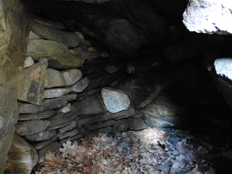
Quartz
block in the interior of a stone chamber at America's
Stonehenge (pic copyright:
Andrew Collins, 2015).
In
addition to this, pieces of quartz, including a triangular stone, have been found
deposited in other New England chambers, while both America’s Stonehenge
and a stone chamber named the Bear’s Den, near New Salem, Massachusetts,
sit close to recognisable quartz veins. It is my reckoning that white quartz was
seen by the stone builders as a portal or point of access to otherworldly environments,
perhaps replacing the seelenloch, or soul holes, found in many megalithic dolmen
structures in Europe, Western Asia, and even in India. Quartz most likely served
as a means for the soul of the deceased or that of the shaman to enter the otherworld.
So while the stone chambers were like entrances to the otherworld, the quartz
was the hole through which absolute access was achieved.
One cannot help
but link the shiny, sparkling quality of quartz with the light seen by people
during near death experiences. By entering this light the deceased finds access
to the afterlife. Is it possible that the Native Americans were also aware of
this process of “seeing the light” at the moment of death, and somehow
came to link it with the properties of quartz? Was quartz connected in some manner
with the Native American death journey, the soul’s entry into the afterlife?
AMERICA’S STONEHENGE
One place I visited for the first time
on this trip was America’s Stonehenge, a megalithic complex made up of a
series of stone-lined chambers, standing stones and stone enclosures built on
the slopping bedrock of a hillside close to North Salem, New Hampshire. I had
read about this site many years ago, but had been dissuaded from taking much interest
in it after reading that it had been built either by Phoenicians or Irish hermits
reaching the Americas long before the age of Columbus.
Archaeologists
dismiss America’s Stonehenge as the handiwork of an early settler named Jonathan
Pattee who occupied the site during the late eighteenth, early nineteenth century.
Indeed, the site was once known as Jonathan Pattee’s Cave. He even built
a house on part of the ruins, in which he is said to have sheltered slaves during
the Civil War. However, as he never claimed to have built it, and radiocarbon
dates obtained from stone walls and charcoal from fire pits have produced dates
varying between 1700 to 300 BC there is clear evidence of a greater antiquity
attached to the site.
Andrew
Collins in a stone enclosure at America's Stonehenge
(pic copyright: Andrew
Collins).
Despite
all the conflicting stories about its origin, America's Stonehenge still seemed
worth a visit. All I can say is that the site is extraordinary, its main stone
enclosure, with large megalithic stones standing in dry stone walls, reminded
me of key megalithic complexes in the old world, such as Göbekli Tepe in
southeast Anatolia, those in Malta and Sardinia in the Mediterranean, and even
other examples in Great Britain. I saw nothing here that suggested the site dated
to colonial times, or that it was a hermitage built by Irish monks! I also saw
no evidence of Baal worship, although I don’t dismiss the likelihood of Phoenician
or Canaanite traders reaching New England as early as 2000 BC. Indeed, I discuss
this possibility in my book Gateway to Atlantis.
Yet the complex does
not end here. Directly above it to the north were once two rock mounds side by
side, although neither exist today. From here the observer would have been able
to look out towards a series of standing stones set within distant boundary walls.
The largest mark important solar events of the calendar year, including the risings
and settings of the sun at the equinoxes and solstices as well as the four cross-quarter
days. Others mark the maximum and minimum risings and settings of the moon during
its 18.61-year lunar standstill cycle. Still another stone, located in the north,
marks the direction of the celestial pole, around which, in a tight circle, revolved
a former Pole Star named Thuban in the constellation of Draco, the celestial dragon.
Smaller stones either side of the “True North Stone” are thought to
mark the extent of this tight circle made by Thuban around the year 1750 BC.
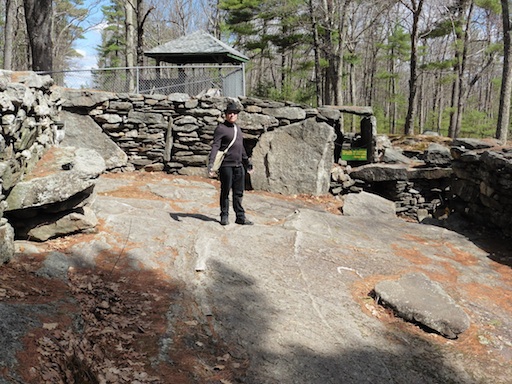
America's
Stonehenge with the famous Slaughter Stone behind
the standing stone in the
foreground (pic copyright: Andrew Collins, 2015).
STAR
ALIGNMENTS EXAMINED
One further monolith, estimated to be 14 feet in length,
and now lying in four separate pieces some distance to the north-northwest of
the main observation point, was examined by Dr Louis Winkler, an archaeoastronomer
who made a thorough examination of the site’s astronomical alignments during
the 1990s. He found that, when standing, the now fallen monolith would have marked
the extinguishing of a near circumpolar star named Izar (Epsilon Boötis)
in the constellation of Boötes, the heavenly ox driver or ploughman, ca.
2000 BC. He felt this made sense as one of the brightest stars in the northern
night sky is Arcturus, another of Boötes stars, meaning that this constellation,
which is often seen to “drive” or turn the much bigger constellation
of Ursa Major, the great bear, as it revolves around the Pole Star, was perhaps
important to the builders of America’s Stonehenge. Near circumpolar stars,
or grazing stars, are those that make their circuit of the sky and then set, or
simply extinguish immediately above the horizon, before rising again soon afterwards.
Since Winkler had also considered the star Deneb in Cygnus as important at
America’s Stonehenge, I felt it was a good idea to check the proposed alignment
featuring the fallen monolith. I contacted Dennis Stone, the son of Robert Stone,
the owner of the site, who kindly provided the coordinates of both the observation
point, today occupied by a wooden tower containing a compass marker, and also
that of the fallen monolith. British engineer Rodney Hale entered the coordinates
and worked out that the azimuth bearing from the observation tower to the fallen
monolith is 347.6 degrees. He then checked the setting of near circumpolar stars
at this azimuth for the date 2000 BC (+/- 1000 years). What he found was interesting,
for it seems Dr Winkler was correct – in 2000 BC the star Izar did indeed
extinguish in line with the fallen monolith when viewed from the observation tower
(this calculation is based on an extinguishing elevation of 2º above the
horizon). However, there is a problem, as due to the fact that the alignment is
so close to north, any near circumpolar star extinguishing at this azimuth only
synchronize with the position of the monolith for around 100 years. This is due
to its shifting position caused by the process of precession, the slow wobble
of the earth’s axis across a cycle of around 26,000 BC. What this means is
that if the alignment between the fallen monolith and Izar was indeed created
around 2000 BC it would have been good for only a century. After that the star
would have drifted too far away from the stone marker to have had any impact.
If, on the other hand, America’s Stonehenge was constructed in any other
epoch, then the importance of Izar evaporates into thin air, as at no time before
or after does it synchronise with this stone. Deneb fairs little better, synchronizing
with the monolith only in around 8000 BC. If we were to find that America’s
Stonehenge was built at this time, then Deneb might become important, otherwise
it is not a contender.
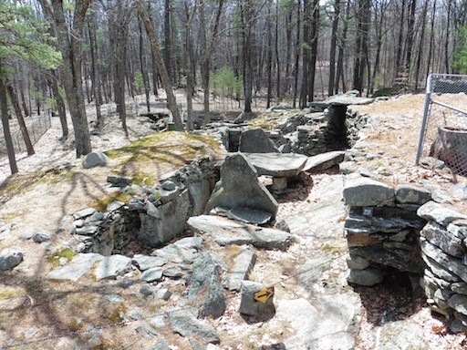
Greg
and Lora Little examine a stone enclosure at America's Stonehenge
(pic credit:
Andrew Collins, 2015).
So
where does this leave us? The honest truth is that until we know the exact construction
date of America’s Stonehenge, the proposed alignment to Izar can still stand.
All I can say right now is that America’s Stonehenge is a remarkable
place, and I urge my American friends wherever you are to pay this site a visit.
You will not be disappointed, and check out a few of the stone chambers locally
as well.
Until next time, happy questing!
Andrew Collins
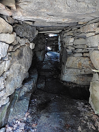
Inside
one of the chambers at America's Stonehenge
(pic copyright: Andrew Collins,
2015)