![]()
![]()
RADAR
SATELITE IMAGE REVEALS THE FULL GEOLOGICAL EXTENT OF GIZA'S CAVE UNDERWORLD.
PLUS
A FULL REPORT ON THE CAVES' FORMATION AND AGE
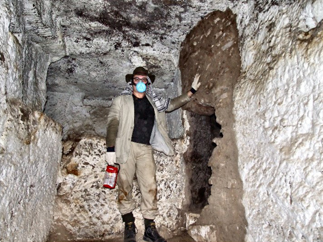
Andrew
Collins emerges from Giza's cave underworld in April 2008.
By
Andrew Collins
Confirmation
that the caves discovered in the north cliff of Giza's famous plateau by myself
and my colleagues in March 2008 reach beneath the central pyramid field has now
been established. Radar satellite imagery of the Giza plateau created by the TerraSAR-X
satellite, launched in 2007 and operated jointly by Astrium GmbH and the German
Aerospace Centre (DLR), shows a shadow line, running from the proximity of the
Tomb of the Birds towards the south, that corresponds pretty well with the positioning
beneath the ground of the caves explored so far. Nothing is visible on the ground
in the corresponding Google satellite image taken, coincidentally, around the
same time in 2007, making this shadow line a mystery, especially as the the TerraSAR-X
satellite programme is promoted as being able to detect underground features.
More incredible is the fact that the shadow line on the TerraSAR-X radar satellite image seems to connect with another wider shadow line that starts at a position corresponding to a gully in the plateau's northern cliff, just west of the Tomb of the Birds, and curves towards the Second Pyramid, where it is finally lost from sight on the north side of the monument's square base. Once again, there are no visible features on the corresponding Google satellite map to explain this anomaly (actually, a second, more fainter, shadow line is also seen on the radar satellite image. It commences in the proximity of the caves explored so far and curves towards the Second Pyramid, where it is lost, finally, as it approaches the west side of the pyramid).
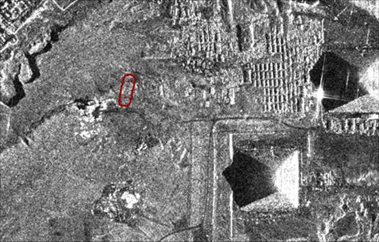 | The
section of the TerraSAR-X radar satellite image of the Giza plateau showing a
shadow line corresponding to the course of the cave tunnels explored to date (Picture
credit: Astrium GmbH and the German Aerospace Centre (DLR)). |
| The curved shadow line on the TerraSAR-X radar satellite map that seems to show the course either of the caves, or localised faulting, which itself might highlight the course of subterranean caves. Note that it disappears on the northwest corner of the Second Pyramid (Astrium GmbH and the German Aerospace Centre (DLR)). | 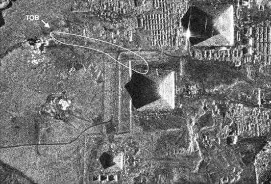 |
It
would be great to consider that this curving shadow anomaly, traced from the area
of the caves reached by ourselves to the proximity of the Second Pyramid, shows
the course of the caves. This is indeed possible, although the operators of the
TerraSAR-X satellite have been unable to comment on the anomaly, saying only that
to date they have a relatively limited understanding of just how far their radar
technology is able to record sub-surface or subterranean features.
If the
shadow lines here described do not mark the course of actual caves, I still suspect
that they represent physical features on the plateau. I believe they trace the
course of local faulting, which would itself mark the most probable path of subterranean
caves carved out by the actions of water across tens if not hundreds of thousands
of years.
If correct, then the fact that the shadow lines disappear in
the vicinity of the Second Pyramid is very interesting indeed. Not only did the
Second Pyramid mark the location of the hidden cave-tomb of Hermes in medieval
Sabaean tradition, but in 1977 a scientific survey conducted jointly by the Stanford
Research Institute (SRI) and the Ain Shams University, Cairo, used ground penetration
radar (GPR) equipment to search for subterranean structures beneath the plateau
at Giza. Aside from some interesting discoveries in the area of the Sphinx, the
team, under the leadership of geophysicist Lambert T. Dolphin, detected the presence
of previously unknown chambers in the vicinity of the Second Pyramid. One, at
least, was situated beneath Belzoni's Chamber inside the structure, while another
was found beneath the monument's northwest corner on the west side (Dolphin, 1977).
Additionally, the team noted the presence of localized faulting on the northwest
corner of the Second Pyramid, adding weight to the conclusion that the shadow
lines shown on the TerraSAR-X radar satellite imagery really do record the presence
of either sub-surface or subterranean geological features.
Since the Tomb
of the Birds is approximately 517 yards (473 meters) from the northwest corner
of the Second Pyramid, I now suspect that it was into this area that Salt and
Caviglia journeyed underground in 1817, this distance constituting the "several
hundred yards" they travelled before reaching the reported spacious chambers,
from which went other passages. If so, then this is a very interesting realization
when we recall the Sabaean belief that the Second Pyramid marked the position
of the cave-tomb of Hermes.
Is
it possible that the bird cult once associated with this site honoured Hermes,
the Graeco-Egyptian form of the Egyptian god Thoth, the keeper of ancient records
and guardian of the ancient wisdom? If correct then future excavations inside
the tomb and caves might well reveal that the bird mummies purportedly left here
as ritual offerings (and found by Vyse and Perring in 1837) contained the remains
of ibises, a bird sacred to Thoth-Hermes. If the birds found here were not ibises,
but raptors, such as hawks and falcons, then the cult here was probably that of
Sokar, the guardian of the Duat of Memphis, or Rostau, the ancient name for Giza.
Either solution will go some way to prove that the Tomb of the Birds was seen
as an entrance into a cave underworld.
According to medieval Arab and European
sources the cave-tomb of Hermes (Idris, or Enoch, as he was called in Arabic)
housed not only the earthly remains of its owner, but also the so-called Emerald
Tablet (also known as the Tabula Smaragdina, the "table of green stone")
on which was written the "secret of Hermes", or the secrets of creation.
Is it possible that legends relating to the presence in the cave-tomb of the Emerald
Tablet is a metaphor for a previously unknown structure at Giza with green stone
walls and inscriptions recording the secrets of Egyptian creation? Alternatively,
perhaps the Emerald Tablet really did once exist, and was discovered here at some
point in the past.
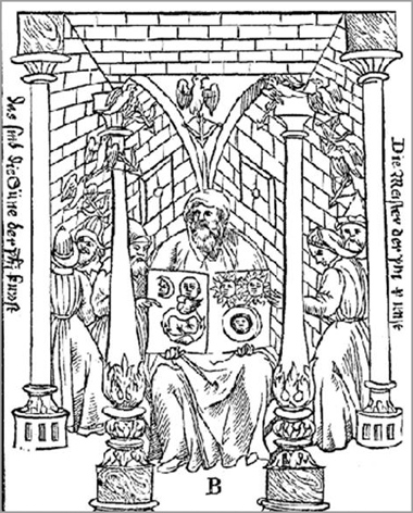
Hermes
Trismegistus holding the Emerald Tablet.
His cave-tomb was thought to be at
Giza
marked by the Second Pyramid
The
Caves' Geology and Formation
The cave system's key-hole shaped profile
and the smoothness of the walls makes it clear that the caves are of natural origin.
Limestone, like that present in the Giza bedrock, is dissolved over time by the CO2 content of rainwater taking the path of least resistance through natural faults in the rock.
Where this occurs above the local water table, the resulting caves are v-shaped in profile, being caused as the water erodes away the rock, as opposed to dissolving it. This type of cave is described by geologists as vadose.
Where water flowing through faulting actually passes beneath the water line of the local water table, it moves more slowly and actually dissolves (as opposed to eroding) the rock, enlarging the cracks and fissures in the process. The resulting cave passages are circular in profile, and tube shaped in appearance. This type of cave is described as phreatic.
Where the two types of cave - phreatic (circular) and vadose (v-shape) are found together, one on top of the other, creating a key-hole shaped profile, it means both types of cave creation were involved. Initially, the rainwater has passed through the fissures beneath the water table, carving circular caves. Then afterwards, when the water table lowers, if the water continues to flow through the caves, it carves a v-shaped trough at the base of the circular profile, producing a perfect key-hole shaped profile, which is what we see in the picture.
Since this is seen in the caves at Giza, it implies that at first the rainwater must have flowed beneath the level of the water table, but then at some point this water table lowered, creating the profile we see today. Thus parts of the Giza caves are both phreatic and vadose in nature.
The fact that the cave walls are often smooth, particularly in the deeper areas, is further confirmation of their creation by rain water, for as one correspondent on the subject of cave formation at Giza has noted:
"The smooth black layers [seen in the photos] are magnetite [Iron(II,III) oxide (Fe3O4) or ferrous ferric oxide], note that Magnetite forms readily when iron oxidizes underwater. This fact plus the smoothness of the layers confirms that these passages were originally flooded, i.e. phreatic in their formation."
"To summarise the plateau was at one time fully saturated, either under water or continuously subjected to torrential rains. This water flowed through natural fault lines creating phreatic passages and caves. As the rainfall eased the water table fell and passages became vadose in shape.
"This fall in the water table was slow enough to allow magnetite to form in the lower passages.
"Roughly parallel events can be seen in the Cheddar cave systems although more intense as there was also ice melt as well as rainfall."
Swallets
and Resurgencies
This same correspondent, well versed in the subject of cave formation, goes on to suggest that we look for "swallets" and "resurgencies", holes through which the rainwater originally found entrance into the faulting to create the caves in the first place. These, he thinks, will most probably be inactive now, the entrances hidden by sand. Swallets, he says, are found mostly on hills, while resergencies are located generally at the base of hills.
The most obvious swallet, as a point of entry for the rainwater that created the caves at Giza, must have occupied a position now taken by the entrance to the Tomb of the Birds, which is located close to the highest point on the plateau. It is likely that at some point in dynastic times the crack or fissure leading into the caves, was expanded to create the rectilinear structures seen today inside the tomb. In doing so, the ancient Egyptians created an access point into the cave system, which was afterwards, perhaps, sealed off using stone and mortar.
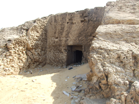 Above, the facade and entrance to the Tomb of the Birds (NC2) in Giza's north cliff, and right, its entrance as seen in March 2010 with a gate cemented in place. Was this the location of a swallet, a fissure that allowed rainwater to enter into the bedrock and carve out the caves prior to the existence of the tomb? Were the caves accessible prior to the Pyramid age?. |
Pic credit: Larry Hunter, 2010. |
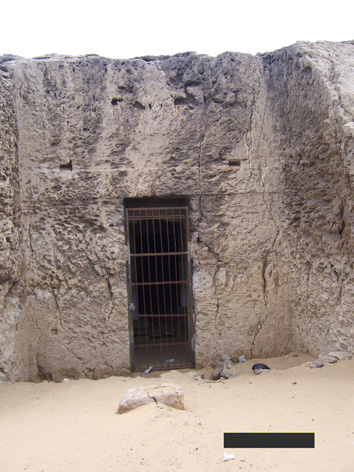
In a personal email to me, Dr Hawass alluded to the tomb NC2 as being of Old Kingdom construction. If this is correct, and counters his earlier assertions that the tomb is of Late Dynastic origin, then it means that the caves were certainly accessible during the Pyramid age. Yet if the Tomb of the Birds began as a swallet, then it suggests that the caves might have been accessible long before this time.
One of the most obvious resurgencies found in association with the Giza cave complex is a spring in the southwest corner of the plateau. Located today in the local cemetery beneath the gaze of Gebel Gibli, the southern mount, it is said by the inhabitants of the nearby village of Nazlet el-Samman, to be an entrance into an underground tunnel system. We have even spoken to a local person who has actually been down the well and seen horizontal shafts at its base heading away towards the east and west.
Without knowing of the existence of this well, known as Bir el-Samman, my geological correspondent wrote: "At Giza if there is an active spring or springs at the foot of the plateau there must be a source of water in the lower cave passages, either seepage or an actual trickle along the cave floor.
"To verify a connection one normally adds fluorescent dye to the water, a harmless and highly visible dye, then looks to see if this appears in the spring water."
All this throws new light on the formation of the Giza caves, which seem unquestionably to be natural in origin, yet utilised by man once exposed. As to their age, this is difficult: they could have formed any time between the beginning of the Middle Palaeolithic era and the end of the Late Palaeolithic age, thus between 250,000 years ago and 12,000 years ago.
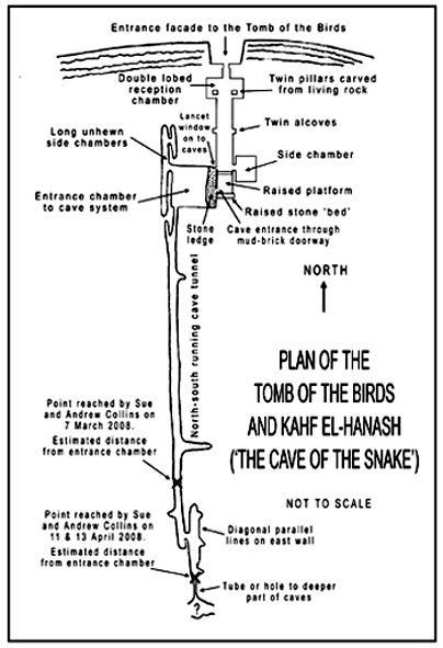
The layout of the Tomb of the Birds and connected caves, showing the farthest points reached during our visits in March and April 2008. | The Stone Tube Our speculation is that the stone tube encountered at the end of the farthest part of the caves explored so far connects with a further east-west orientated chamber just beyond its exit. If so, then this could be the beginning of the proposed southwest extension of the caves as they head out towards the direction of the Second Pyramid. Yet the question is whether or not the stone tube does indeed provide access to a deeper section of the caves. This is something we might now never find out. Oh, how we wish that we had gone further on our final visits to the caves in April 2008. What does lie beyond the stone tube? You can speculate, as I have done, but no one knows, unless, that is, Dr Hawass and his team did what we now only dream of and went further. |
References
Dolphin, Lambert T., A. H. Moussa et al, Applications of Modern Sensing Techniques to Egyptology, SRI Institute, Menlo Park, CA, September 1977.
Thanks
go out to Ian for his help in attempting to determine the forces behind the creation
of the Giza caves; Robin Rix for putting us in contact; also for Larry Hunter,
Nigel Skinner Simpson and Rodney Hale for their help in putting this piece together.
For
more information on the Giza cave discoveries check into this website regularly,
subscribe to the Andrew Collins newsletter, or see Andrew Collins's book BENEATH
THE PYRAMIDS, available now. See below for details of purchase.
For
a comprehensive introduction to Andrew Collins's
new book Beneath the Pyramids,
which features the quest behind the discovery of Egypt's cave underworld, click
here
To
buy BENEATH THE PYRAMIDS, Andrew's new book on the quest to find Giza's cave underworld,
from Amazon click here.
To
buy straight from the publisher, 4th Dimension Press, click here.
Secure
the special edition of BENEATH THE PYRAMIDS signed, numbered and stamped direct
from the author by clicking here and sending
an email with "Beneath the Pyramids" in the contents box (with no final
obligation to buy).
![]()
![]()